Kudat — Sabah's First Colonial Capital and Home of the Rungus People
Why was Kudat chosen as the first capital?
In 1881, when the British North Borneo Chartered Company received its charter and began establishing effective control over the territory, selecting a capital was a strategic priority. The BNCC faced a complex decision: where to place its administrative centre in a vast, uncharted territory occupied by diverse indigenous groups and claimed by competing sultanates?
Kudat, located at the northernmost tip of Sabah, appeared to offer several advantages. First, its geography was defensible. As a coastal location at the northern extremity of the territory, Kudat could serve as a military stronghold protecting the BNCC from potential threats from rival European powers, particularly the Spanish in the Philippines. The natural harbour, though not ideal, provided access for ships and maritime trade.
Second, Kudat's location at the northern point of the territory symbolically asserted British control over the entire region. Establishing the capital there sent a message that the BNCC claimed and held the entire Sabah territory from north to south.
Third, Kudat had existing trading networks. Chinese merchants and Sulu traders had long maintained contact with the Kudat area, so the BNCC could leverage existing commercial relationships and infrastructure.
However, the BNCC founders, including William Cowie and Alfred Dent, appear to have underestimated the challenges of administering a colonial territory from such a remote northern location. Kudat was geographically isolated from most of the populated regions of North Borneo. The journey from Kudat to the interior or to the southern coast was arduous. Additionally, the climate was hot and humid, diseases were rampant, and the supply lines for provisions and materials were tenuous. These factors would prove to be critical liabilities within just a few years.
Kudat as capital 1881-1883
When the BNCC formally began administering British North Borneo in 1881, Kudat became the seat of government. Fort Cowie, named after William Cowie, was constructed as the administrative centre and military stronghold. The fort housed the resident governor (the chief BNCC administrator), military barracks, government offices, and residential quarters for European officials.
Life in Kudat during this period was difficult and precarious. The small European community faced tropical disease, particularly malaria and dengue fever. Supply ships from Europe or British colonies took months to arrive, and communication was slow. The European population was tiny—perhaps a few dozen to a few hundred officials, traders, and soldiers. Boredom, isolation, and health challenges made posting in Kudat one of the least desirable assignments in the British empire.
Despite these hardships, the BNCC established basic administrative structures during the Kudat period. A colonial government was formed, tax collection systems were implemented, and initial forays into resource extraction began. Chinese merchants and miners began arriving, establishing trading posts and engaging in tin mining and other commercial activities. The Rungus people and other indigenous groups had their first sustained contact with colonial administration.
The BNCC also began developing the territorial claims it had acquired through concessions from the Brunei and Sulu sultanates. Exploration expeditions were dispatched to map the interior and establish the extent of BNCC control. Military patrols were conducted to assert authority over coastal and nearby interior regions.
However, the Kudat capital period was always intended to be temporary. The BNCC administrators quickly recognised that a more centrally located and more accessible capital was necessary for effective colonial governance. The isolation of Kudat, combined with its poor harbour and limited commercial potential, made it an impractical long-term administrative centre.
Why the capital moved to Sandakan
In 1883, only two years after establishing Kudat as the capital, the BNCC made the decision to relocate the seat of government to Sandakan, a location on the east coast of North Borneo. This move reflected a strategic reassessment by BNCC leadership.
Sandakan offered several critical advantages over Kudat. First, it had a superior natural harbour. The deep, protected waters of Sandakan Bay could accommodate larger ships and provide safer anchorage for the growing maritime trade. Kudat's harbour, while usable, was exposed and limited in capacity.
Second, Sandakan was positioned on the Sulu Sea and Celebes Sea, giving it access to crucial regional trade routes. This location was ideal for commerce with Jolo (in the Sulu sultanate), Celebes, Makassar, and other Southeast Asian trading centres. Kudat, at the northern tip, was peripheral to these main trade routes.
Third, Sandakan had greater commercial potential. The region surrounding Sandakan was rich in timber resources, and Chinese merchants and logging companies were eager to operate in the area. Sandakan could develop into a genuine trading port and commercial hub, whereas Kudat remained a remote administrative post. The BNCC, as a profit-seeking chartered company, recognised the commercial promise of Sandakan and prioritised relocating there.
Fourth, Sandakan's location was more defensible in the long term. Although Kudat appeared defensible at the northern tip, Sandakan's position on the east coast gave it better access to the Sulu sultanate's domain and provided strategic depth for the colony. It was less isolated and more integrated into regional politics and commerce.
The relocation of the capital from Kudat to Sandakan happened gradually between 1883 and 1884. Key administrative offices, military personnel, and the governor's residence were transferred to Sandakan. Kudat was demoted from capital to a secondary garrison and trading post. However, it remained strategically important as a military fortification and northern outpost of the BNCC territory.
The Rungus people of Kudat
The Rungus people are the indigenous inhabitants of the Kudat region and surrounding areas. They are one of several Kadazan-Dusun subgroups in Sabah and are known for their distinctive longhouse culture, intricate beadwork, and preservation of traditional customs. The name "Rungus" itself comes from the local word for longhouse (rumah).
Before colonial contact, the Rungus lived in independent longhouse communities scattered throughout the interior near Kudat and surrounding regions. Each longhouse was home to an extended family or clan of 30-100 people. The Rungus practised swidden agriculture (shifting cultivation), growing rice, maize, and vegetables, supplemented by hunting, fishing, and gathering. They maintained strong communal bonds, with elders serving as decision-makers and arbiters of disputes.
The Rungus are particularly renowned for their beadwork and textile arts. Rungus women create intricate beaded necklaces, earrings, and ornaments using traditional techniques passed down through generations. These beaded items are not merely decorative; they serve social functions, marking wealth, status, and identity. The beadwork of the Rungus is among the most distinctive and admired in Sabah and has become a significant aspect of cultural tourism.
Traditional Rungus society emphasised headhunting as a ritual practice, similar to other indigenous groups in Sabah. Headhunting raids marked transitions, asserted warrior status, and served spiritual purposes. When the British banned headhunting, the Rungus, like the Murut, experienced this as cultural suppression, though they did not mount organised armed rebellion against British rule.
The Rungus responded to colonialism primarily through cultural persistence. Despite British pressures to adopt Christianity, English language, and Western dress, many Rungus communities maintained their longhouse settlements, language, and traditional practices. This cultural resilience has made the modern Rungus one of Sabah's most culturally intact indigenous groups. Visitors to Kudat can experience Rungus longhouse communities, observe traditional beadmaking, and participate in cultural activities that have been preserved for generations.
Kudat after the capital moved
After 1883, Kudat transitioned from being the political centre of British North Borneo to being a secondary garrison and trading post. However, it did not decline into insignificance. Fort Cowie remained an important military installation, and Kudat continued to attract merchants and traders, particularly Chinese merchants engaged in tin mining, trading, and commerce.
The period from 1883 until the early 20th century saw Kudat develop as a trading centre. Chinese merchants established shops, warehouses, and mining operations. The port, though not ideal, remained functional for trading vessels. An administrative residency continued to operate, overseeing the northern region on behalf of the BNCC. The population grew gradually, comprising Chinese merchants, European officials, and indigenous Rungus and other groups.
During the late 19th and early 20th centuries, Kudat was known as a rough and somewhat lawless frontier town. The remoteness and small colonial presence meant that authority was lighter than in Sandakan, and traders and adventurers operated with considerable freedom. The town attracted gamblers, merchants, and opportunists seeking to profit in the frontier economy.
The Japanese occupation of North Borneo during World War II (1942-1945) affected Kudat significantly. The British colonial administration withdrew, and the Japanese military established control. Kudat was fortified as a military position and endured bombing by Allied forces. Much of the town was damaged or destroyed during the war.
After the war and Sabah's eventual independence in 1963, Kudat gradually modernised. It developed as a small city, the centre of the Kudat district. Fishing became a major economic activity. The town's role shifted from a colonial administrative and trading post to a modern district centre serving local communities and supporting fishing and tourism industries.
What to see in Kudat today
Tip of Borneo (Tanjung Simpang Mengayau). The most iconic attraction in the Kudat area is the Tip of Borneo, the northernmost point of the island. This geographic landmark offers scenic views of the Sulu and Celebes seas converging. The site is a natural tourist destination where visitors stand at the literal tip of Borneo and take photographs. The area includes interpretive signs explaining the geography and history.
Rungus longhouse communities. Several Rungus longhouses near Kudat remain inhabited and are open to visitors. These traditional settlements offer opportunities to experience indigenous architecture, observe beadmaking demonstrations, participate in traditional cooking, and learn about Rungus culture directly from community members. Homestays and cultural tourism activities are available.
Colonial-era ruins and heritage sites. While Fort Cowie itself no longer stands intact, the general location of the colonial fort can be identified, and some ruins and structural remains are visible in the Kudat area. Local guides can point visitors to significant colonial heritage sites, including the location of government buildings and other BNCC-era structures.
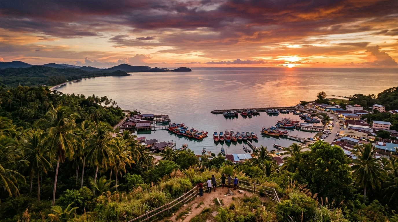
Kudat town and markets. The modern town of Kudat offers markets, shops, and restaurants serving local cuisine. The coastal area provides opportunities for fishing, boating, and seafood dining. The town is a functional district centre where visitors can experience contemporary Sabah life in a smaller, less urbanised setting than Kota Kinabalu.
Marine and coastal activities. The waters around Kudat offer diving, snorkelling, and fishing opportunities. Nearby islands can be visited by boat. The marine environment is rich in biodiversity and offers adventure activities for visitors.
Kudat's place in modern Sabah
Today, Kudat is the second-largest town in the Kudat district and serves as the administrative and economic centre for the northern region of Sabah. The town has a population of approximately 30,000-40,000 people. While it is much smaller than Kota Kinabalu or Sandakan, Kudat is significant in its regional context.
The economy of Kudat is centred on fishing, with a productive port handling fish and seafood products destined for markets throughout Sabah and Malaysia. The town also serves as a transit point for visitors heading to the Tip of Borneo and as a base for accessing Rungus cultural attractions. Government offices, schools, hospitals, and other infrastructure serve the district population.
Kudat's historical identity remains significant. The town is conscious of its role as the first capital of British North Borneo and as the home of the Rungus people. Educational institutions teach local history, and there is growing interest in heritage preservation. However, Kudat is not primarily defined by its colonial past—it is a living, functioning town where Sabahans work, live, and pursue contemporary livelihoods.
The transition from colonial capital to regional fishing centre and cultural tourism destination reflects Sabah's broader trajectory from colonial territory to independent state. Kudat exemplifies how colonial-era infrastructure and institutions have been adapted and repurposed to serve contemporary communities. The fort is gone, but the geographic significance of the location remains. Colonial administrators are long departed, but the indigenous Rungus people continue to inhabit their ancestral lands, maintaining cultural traditions while engaging with the modern world.
| Year / Period | Capital Status | Key Significance |
|---|---|---|
| 1881 | First capital | BNCC charter granted; Fort Cowie established; colonial administration begins |
| 1881-1883 | Capital | Kudat serves as administrative centre; challenges with isolation and disease become apparent |
| 1883 | Capital transferred | Capital moved to Sandakan; Kudat becomes secondary garrison and trading post |
| 1883-1941 | Regional post | Kudat develops as trading centre; Chinese merchant community grows; military importance declines |
| 1942-1945 | Japanese occupation | Town occupied; fortified; damaged by Allied bombing |
| 1945-1963 | Post-war recovery | British colonial administration resumes; town rebuilds; prepares for independence |
| 1963-present | District centre | Sabah independent; Kudat becomes fishing and tourism centre; Rungus culture preserved |