Fort Cowie Kudat — Remnants of Sabah First Colonial Fortification
What was Fort Cowie?
Fort Cowie was a military fortification built in Kudat between approximately 1881 and 1883 by the British North Borneo Chartered Company (BNCC). It served as the primary defensive structure of Kudat, which was then the capital of British North Borneo—the BNCC-administered territory that would eventually become the state of Sabah.
The fort was a physical manifestation of European military power in a newly colonised territory. Like many colonial forts, it was designed to serve multiple functions: defence against external threats, demonstration of military capability to local populations, and provision of secure headquarters for colonial administration and commerce.
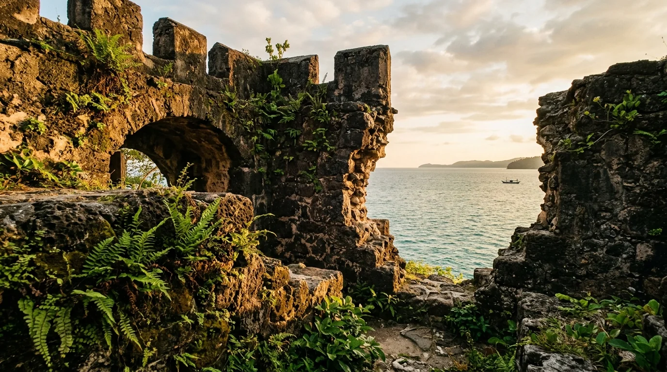
Today, Fort Cowie exists primarily as ruins and archaeological remains. The fortification structures—buildings, walls, stockades—have been largely destroyed or degraded by time, weather, and the destruction of WWII. What remains are fragments and historical records, making the site more important as a symbolic and historical landmark than as a visually intact structure.
The name "Fort Cowie" itself carries historical weight, referencing William Cowie, a key figure in the establishment and early operation of the BNCC. The choice to name the flagship fort after a co-founder underscores the fort's importance and its association with the founding narrative of European rule in Sabah.
Why the BNCC needed a fort in Kudat
When the BNCC began establishing control over the territory in the late 1870s, it faced multiple security challenges. First, local chiefs and populations—particularly Bajau pirates and interior tribal groups—had not consented to BNCC rule. Armed resistance was a real possibility. Second, piracy and armed raids were common in the region. The Sulu Sea had long been a domain of Bajau sea-rovers and pirate networks. Third, other European powers (Spanish, Dutch) had colonial interests in the region, and territorial disputes were ongoing.
A fortified military presence was therefore essential. The fort served to: deter local resistance; provide military capacity to enforce BNCC authority; protect European personnel and commercial interests; and project power to rival colonial powers and local actors. Kudat, with its advantageous location and harbour, was the logical location for this first fort.
The fort was also a symbol. A visible military structure demonstrated that the BNCC was serious about control and possessed the military means to enforce it. For local chiefs and populations, the fort was a constant physical reminder of European military superiority. This psychological dimension of colonialism was as important as its military functionality.
Over time, as BNCC rule solidified and armed resistance diminished, the need for heavily fortified positions decreased. But in the early 1880s, when the company was consolidating its position, Fort Cowie represented a critical investment in territorial security and administrative foundation.
Named after William Cowie, BNCC co-founder
William Cowie (also known as William Clarke Cowie) was a Scottish merchant and one of the founding figures of the British North Borneo Chartered Company. He was instrumental in the company formation, capital raising, and early commercial operations in British North Borneo. The choice to name the primary fort after Cowie reflected his significance to the BNCC and to the colonial project as a whole.
Cowie was not merely an investor or figurehead—he was actively involved in the early operations and negotiations. He participated in securing agreements with local chiefs, in establishing the commercial framework for BNCC operations, and in defending the company against competing European interests. He was, in many ways, the public face of BNCC early authority.
The naming of Fort Cowie was thus an act of commemoration and legitimacy. By naming the fort after a co-founder, the BNCC was embedding Cowie and the company into Sabah territorial and institutional history. The fort became associated not just with military defence, but with the founding vision and leadership of the company.
William Cowie died in 1889, before the fort was abandoned. He therefore never witnessed the decline of Kudat as a colonial capital or the fort relegation to historical ruin. The fort remained a standing testament to his role in founding European rule in Sabah until its destruction in WWII.
Kudat as the first capital of British North Borneo
From 1881 to 1883, Kudat was the administrative capital of British North Borneo. This status reflects the geopolitical calculations of the BNCC. Kudat offered a natural harbour, strategic location in northern Sabah, and relative accessibility. The BNCC established its administrative headquarters in Kudat, and Fort Cowie served as the military and administrative centre.
Kudat in the early 1880s was a frontier town. Europeans, Chinese merchants, and Bajau and Malay traders coexisted in a rough-and-tumble trading environment. Disease (malaria, dysentery) was endemic. The climate was harsh. Infrastructure was minimal. Yet Kudat represented the forward edge of European expansion and commercial opportunity.
The capital was relocated to Sandakan in 1883, a decision driven by practical considerations. Sandakan offered a better harbour, more suitable terrain for expansion, and superior strategic positioning. The move reflected the BNCC evolution from a trading company establishing initial foothold to a more sophisticated colonial administration seeking optimal administrative and commercial locations.
Kudat's status as a former capital is historically significant. Few places experience the rise and fall of capital status. For Kudat, the shift from capital (1881-1883) to secondary administrative centre was a decline, but it did not erase the town identity as a place of historical importance. The memory of being Sabah first capital has been maintained in historical narratives and local identity.
What happened when the capital moved to Sandakan
When the BNCC relocated its capital to Sandakan in 1883, Kudat lost its administrative primacy. The fort, which had housed the company governor and senior staff, became less strategically important. Rather than dismantling it, the BNCC likely maintained it as a secondary administrative and military post, but its resources and priority diminished.
The relocation began a period of relative decline for Kudat. While the town remained a trading and administrative centre, it no longer served as the seat of power. Commercial activity shifted to Sandakan, and population migrated accordingly. Over the following decades, Kudat became a peripheral rather than central node in the BNCC colonial network.
This transition, though not as dramatic as the complete abandonment of a settlement, represented a significant historical shift. Kudat went from being the symbolic and administrative heart of European Borneo to being a regional outpost. The fort, once a symbol of colonial power and authority, became a symbol of a past era.
By the early 20th century, nearly half a century after its construction, Fort Cowie was likely in a state of disrepair. Tropical weather—heavy rains, humidity, salt spray—rapidly degrades structures. Lack of active military use and minimal maintenance meant the fort slowly deteriorated. By the time WWII arrived, the structure was already compromised.
WWII and the fort condition under Japanese occupation
When Japan invaded British North Borneo in 1942, the territory was occupied and incorporated into the Japanese defensive network. Kudat, despite its decline as a colonial administrative centre, was militarily relevant due to its location and potential for strategic importance.
It is unclear whether the Japanese actively used Fort Cowie or its remains. The fort was already severely degraded after 60 years of exposure and minimal maintenance. The Japanese may have demolished it to clear the area for their own military structures, or they may have left it to continue deteriorating. Allied bombing campaigns, designed to dislodge Japanese forces and disrupt military infrastructure, also targeted the Kudat region, further damaging historical structures.
By the end of WWII in 1945, whatever remained of Fort Cowie had been largely destroyed. Post-war reconstruction focused on rebuilding civilian and commercial infrastructure, not preserving colonial-era military ruins. Fort Cowie faded from active use into historical memory.
The wartime destruction ironically accelerated the fort transition from a standing structure (even if ruined) to an archaeological site. The clear line between pre-WWII and post-WWII Sabah is marked by physical destruction. Very few pre-war structures survive in northern Sabah, making Fort Cowie even more historically significant as a tangible connection to the founding era of European rule.
What remains and how to visit today
Fort Cowie today exists as minimal physical remains and a historical concept. Depending on preservation efforts and site conditions, visitors may find: stone foundations or rubble indicating fort structures; earthwork traces or topographic features indicating fort layout; interpretive signs or markers (if the site has been formally designated and developed); and views of the surrounding landscape that provide context for the fort strategic location.
The exact accessibility and interpretation of the site depends on current heritage development efforts in Kudat. As of recent years, Fort Cowie is not a heavily developed tourist site with dedicated facilities. However, heritage advocates and local tourism authorities have been working to document and preserve Kudat historical sites.
Visitors interested in Fort Cowie should contact Kudat tourism services or local heritage guides to determine current site conditions, accessibility, and available interpretive resources. A visit might involve: examining remaining physical structures or foundations; understanding the site layout and historical context through available documentation; and considering the landscape to imaginatively reconstruct the fort appearance and function.
Fort Cowie is best visited as part of a broader Kudat heritage exploration. Combining it with Tanjung Simpang Mengayau (Tip of Borneo)—located near Kudat—makes for a meaningful day trip. The two sites represent different aspects of Kudat heritage: Fort Cowie represents colonial history and human political structures; Tip of Borneo represents geography and nature. Together, they provide a fuller Kudat experience.
| Fortifications & Defensive Structures in Colonial British North Borneo | Location | Historical Period | Current State |
|---|---|---|---|
| Fort Cowie | Kudat | 1881-1883 to ~1942 (destroyed WWII) | Ruins and archaeological remains. Minimal visible structure. Heritage site status emerging. |
| Fort Gerstin (defensive structures, Sandakan) | Sandakan | 1880s-1942 | Largely destroyed in WWII bombing. Scattered historical documentation. |
| Batu Sumpah (sacred stone with colonial military significance) | Keningau area | 1880s-1890s (colonial period) | Stone remains. Associated with Murut treaties and British military authority. Standing heritage site. |
| Tawau Fort / Colonial administrative buildings (Tawau) | Tawau | Early 1900s | Some colonial structures remain, modified and repurposed. Not formally a "fort" like Cowie, but administrative military presence. |
| Coastal Defence Structures (various locations) | Multiple (Kudat, Sandakan, Tawau) | Late 1800s-1942 | Mostly destroyed or inaccessible. Historical records more valuable than physical remains. |